Hurricane center says tropical system could target Florida while Tropical Storm Barry forms near Mexico
Published in News & Features
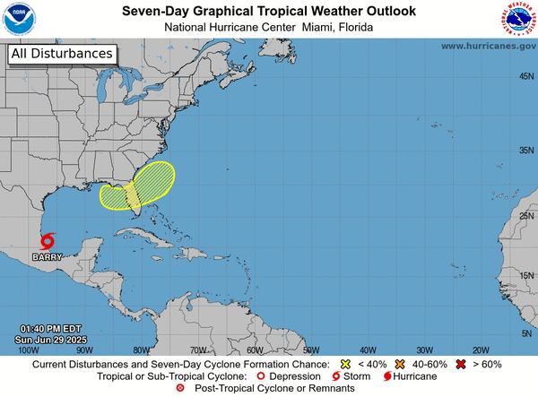
While Tropical Storm Barry formed in Gulf waters off of Mexico on Sunday, the National Hurricane Center began forecasting the season’s next potential tropical system could form and threaten Florida.
In its 8 a.m. tropical outlook the NHC said an area of low pressure from a remnant frontal boundary could develop near the end of this week near either the southeastern U.S. Atlantic of Gulf coasts. Its bubble of potential development sweeps across all of Central Florida.
“Some gradual tropical or subtropical development could occur thereafter as it drifts slowly just off the U.S. coastline,” forecasters said.
The NHC gave it a 20% chance for development in the next seven days.
The National Weather Service in Melbourne said expect a high chance of rain no matter what forms around the Fourth of July and into that weekend.
“The evolution of this stalled boundary and any features that it may help produce remains very low confidence and bears watching. However, the overall forecast thinking remains the same, regardless: high coverage of showers and storms looks to continue each afternoon and evening into next weekend, as deep moisture lingers,” NWS forecasters said.
If it were to develop into a named storm, it could become Tropical Storm Chantal.
That’s because the second named storm of the 2025 Atlantic hurricane season formed Sunday morning in the Bay of Campeche off of the Mexican coast.
As of 11 a.m., the center of Barry was located about 90 miles east-southeast of Tuxpan and 165 miles southeast of Tampico, Mexico with maximum sustained winds of 40 mph moving northwest at 6 mph. Tropical-storm-force winds extend out 35 miles.
A tropical storm warning remained in effect for the Gulf coast of Mexico from Boca de Catan southward to Tecolutla.
“On the forecast track, the storm is expected to make landfall and then move inland over eastern Mexico later today or tonight,” forecasters said. “A little more intensification is forecast before the system reaches the coast of eastern Mexico. Rapid weakening is expected after the system moves inland.”
The system is forecast to drop 3-6 inches with some areas getting up to 10 inches across the Mexican states of Veracruz, San Luis Potosi and Tamaulipas through Monday.
“This rainfall may produce life-threatening flooding and mudslides, especially in areas of steep terrain,” the NHC stated.
The slow start of the 2025 Atlantic hurricane season did not see the first named storm form last week. What would have been Tropical Storm Andrea remained out in the middle of the Atlantic, where it spun for less than a day with no threat to land.
The National Oceanic and Atmospheric Administration, though, still forecasts this year 13 to 19 named storms this year, of which 6-10 will become hurricanes. Three to five of those are predicted to grow into major hurricanes of Category 3 strength or higher.
Hurricane season runs through Nov. 30.
_____
©2025 Orlando Sentinel. Visit orlandosentinel.com. Distributed by Tribune Content Agency, LLC.


Comments