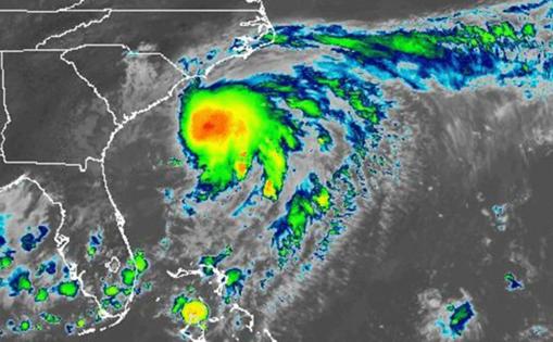
Tropical Storm Chantal strikes Carolina coast
Published in News & Features
Tropical Storm Chantal moved inland Sunday morning, bringing rain and flood threats after striking the Carolina coast with 50 mph winds.
As of the National Hurricane Center’s 11 a.m. advisory, the storm had diminished into a tropical depression with maximum sustained winds of 35 mph as it moved into eastern North Carolina. It was located about 20 miles southwest of Lumberton and 80 miles west of Wilmington, N.C., moving north at 9 mph.
“A turn toward the northeast is expected this evening and that motion should continue into Monday. On the forecast track, the center of Chantal is expected to move over eastern North Carolina through tonight,” forecasters said. “Additional weakening is expected during the next 24 hours, and the system is expected to degenerate into a trough of low pressure on Monday.”
The storm is forecast to drop 2-4 inches of rain, with some areas getting up to 6 inches over portions northeastern South Carolina today and across portions of North Carolina through Monday, bringing with it a threat for flooding.
“An isolated tornado or two is possible today over parts of eastern North Carolina,” the NHC warned.
Rough surf and rip currents are a threat from northeastern Florida to the mid-Atlantic into Monday.
Chantal was the first storm of the 2025 Atlantic hurricane season to strike the United States.
The National Oceanic and Atmospheric Administration forecasts 13 to 19 named storms this year, of which 6-10 will become hurricanes. Three to five of those would grow into major hurricanes of Category 3 strength or higher.
Hurricane season runs June 1-Nov. 30.
_____
©2025 Orlando Sentinel. Visit orlandosentinel.com. Distributed by Tribune Content Agency, LLC.


Comments