Hurricane center ups odds system over Florida will develop
Published in News & Features
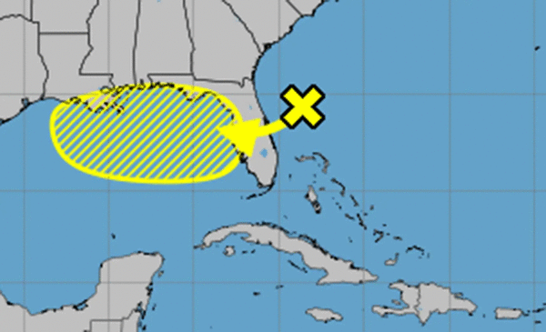
The National Hurricane Center on Monday increased its forecast chances a system already dumping rain on Florida could develop into the season’s next tropical depression or storm.
In the NHC’s 8 a.m. tropical outlook, it stated the trough of low pressure off the Atlantic coast of north Florida was producing disorganized showers and thunderstorms across portions of Florida as well as the northwestern Bahamas and adjacent Atlantic waters.
“This system is forecast to move westward across Florida during the next day or so, and into the northeastern Gulf by late Tuesday,” forecasters said. “Environmental conditions appear favorable enough to support some gradual development of this system while it moves westward to west-northwestward across the northeastern and north-central portions of the Gulf during the middle to latter part of this week.”
The NHC gave it a 10% chance of development in the next two days and 30% in the next seven.
“Regardless of development, heavy rainfall could produce localized flash flooding over portions of Florida and the north-central Gulf coast through the middle to latter portion of this week,” forecasters said.
If it does develop into a named storm, it could become Tropical Storm Dexter.
The National Weather Service in Melbourne said the system could drop 2 inches of rain for much of Central Florida through Tuesday.
“The highest rain chances will be favored across the interior and the Treasure Coast counties today (70-80%),” the NWS stated in its forecasters’ discussion. “Periods of continued rainfall may lead to a localized flood threat, particularly across low lying and poor drainage areas.”
Some areas could see as much as 4 inches of rain, and that could continue as the system moves west and tropical moisture remains over Florida.
“Deep moisture will continue to fuel high rain chances locally (80%). While global ensembles suggest widespread daily rainfall totals of an inch or less, localized totals of 2-4″ remain possible, especially where stronger storms occur,” forecasters stated.
The state was previously doused by rains associated with what developed into Tropical Storm Chantal earlier this month. That storm ended up striking the Carolina coast and dumped flooding rains inland.
The National Oceanic and Atmospheric Administration had before the start of hurricane season forecast an expected 13 to 19 named storms for the year, of which 6-10 would grow into hurricanes. Three to five of those would develop into major hurricanes of Category 3 strength or higher.
Researchers out of Colorado State University this week, though, updated their forecast saying they expect the season to be slightly less busy than what they had predicted earlier this year.
Hurricane season runs June 1-Nov. 30.
-----------
©2025 Orlando Sentinel. Visit at orlandosentinel.com. Distributed by Tribune Content Agency, LLC.


Comments