Hurricane center eyes potential systems near Florida, in Atlantic while TS Dexter churns
Published in News & Features
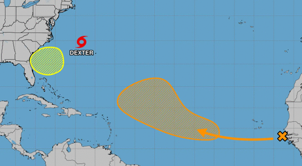
ORLANDO, Fla. — The National Hurricane Center on Monday increased the odds two systems could form into the season’s next tropical depression or storm, including one near Florida’s coast, while newly formed Tropical Storm Dexter continued to churn in the Atlantic.
As of the NHC’s 8 a.m. tropical outlook, forecasters expect a broad area of low pressure to develop in a couple of days a few hundred miles off the coast of the southeastern United States.
“Some gradual development of this system is possible during the middle or latter portion of this week as the system drifts slowly westward to northwestward,” forecasters said.
The NHC gave increased its chances to 30% that it could develop into a tropical system.
The National Weather Service in Melbourne said there could be some interaction with this low and a stalled front draped across the Florida peninsula that extends into the western Gulf.
“There will likely be some interaction between the low and this front before it begins to lift northward this weekend,” forecasters said. “Plumes of higher precipitable weather associated with a mid level wave, look to move over the Florida peninsula Thursday through Sunday.”
Elsewhere in the Atlantic, the outlook also increased odds for development of a tropical wave moving off the coast of Africa that for now only has limited shower activity.
“In a few days, environmental conditions are forecast to become favorable for gradual development of this system, and a tropical depression could form by the latter portion of this week as it moves generally west-northwestward across the central tropical Atlantic,” forecasters said.
The NHC increased odds to 50% that a system could form in the next seven days.
As far as Tropical Storm Dexter, which formed in the Atlantic on Sunday night, the season’s fourth named storm is no threat to land.
As of 5 a.m. Monday, the center of Dexter was located about 255 miles northwest of Bermuda moving east-northeast at 12 mph with maximum sustained winds of 45 mph. Tropical-storm-force winds extend out 115 miles.
“A faster east-northeastward or northeastward motion is expected through early Tuesday, followed by a slower motion Tuesday and Wednesday,” forecasters said. “Some slight strengthening is forecast during the next couple of days. Dexter is likely to become post-tropical by Wednesday.”
Dexter became the fourth named storm following tropical storms Andrea, Barry and Chantal.
After Dexter, the next names on the NHC’s list are Erin and Fernand.
Before the start of hurricane season, the National Oceanic and Atmospheric Administration had forecast an expected 13 to 19 named storms for the year, of which 6 to 10 would grow into hurricanes. Three to five of those would develop into major hurricanes of Category 3 strength or higher.
The height of hurricane season runs from mid-August into October.
The entire six-month season runs June 1 to Nov. 30.
------------
©2025 Orlando Sentinel. Visit at orlandosentinel.com. Distributed by Tribune Content Agency, LLC.


Comments