Hurricane center eyes new Atlantic system while Tropical Storm Gabrielle spins
Published in News & Features
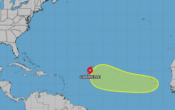
The National Hurricane Center on Thursday continued to track Tropical Storm Gabrielle while also eyeing a tropical wave moving off the coast of Africa that could become the season’s next named storm.
As of the NHC’s 11 a.m. Eastern time advisory on Gabrielle, the system had 50 mph sustained winds located about 755 miles east of the Caribbean’s northern Leeward Islands headed west-northwest at 15 mph. Tropical-storm-force winds extend out 290 miles from its center.
Gabrielle became the season’s seventh named storm after it intensified from a tropical depression that formed earlier Wednesday.
“This motion is expected to continue over the next couple days, followed by a northwestward turn this weekend,” forecasters said. “Little change in strength is forecast during the next 48 hours, but some gradual intensification is forecast over the weekend.”
Its forecast path keeps it away from land over the next five days.
Projections have it growing into a Category 1 hurricane by Monday, which would be only the second hurricane of the season. It’s forecast to turn away from Bermuda, through, and remain in the Atlantic no threat to land.
The NHC was also one more system in the eastern tropical Atlantic.
As of the 8 a.m. tropical outlook, a tropical wave was still over land but forecast to move off the coast of Africa later Friday.
“Some slow development of this system is possible over the weekend through the middle of next week while it moves west-northwestward across the eastern and central tropical Atlantic,” forecasters said.
The NHC gave it a 20% chance to develop in the next seven days.
The next name after Gabrielle would be Humberto.
The climatological peak of the Atlantic hurricane season was on Sept. 10, but 60% of annual activity has historically happened after this date, the NHC stated.
With the new depression, the season has had only seven official storms. The most recent, Tropical Storm Fernand, petered out by the end of August.
The only hurricane had been Hurricane Erin, which grew into a massive Category 5 system with 160 mph winds but remained in the Atlantic without making landfall.
The National Oceanic and Atmospheric Administration in early August updated its season forecast to call for 13-18 named storms this year, of which five to nine would grow into hurricanes. Two to five of those would develop into major hurricanes of Category 3 or higher.
Hurricane season runs from June 1 to Nov. 30.
------------
©2025 Orlando Sentinel. Visit at orlandosentinel.com. Distributed by Tribune Content Agency, LLC.


Comments