Temps across Southern California to soar past 100 degrees. Relentless humidity will make it feel ever hotter
Published in News & Features
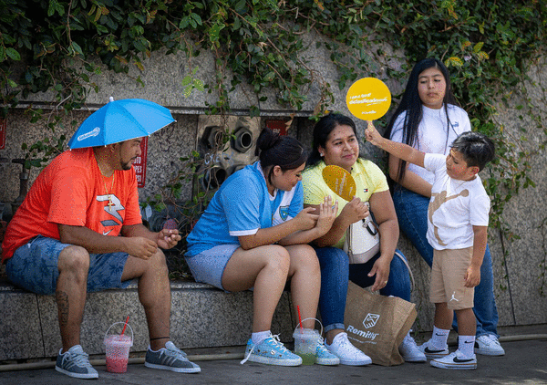
LOS ANGELES — A summer of disgustingly miserable humidity is expected to peak in the coming days with sweltering and dangerous conditions thanks to the influence of Tropical Storm Marie.
The extreme weather, a preview of the intense El Niño conditions forecast for Southern California this winter, will bring temperatures into the 90s and 100s in some areas, but experts say the humidity will make it feel even hotter. The coast will offer little relief, with high surf, intense temperatures and pollution due to the rain.
"All of that tropical moisture is really coming from [the remnants of Marie] leaning into our area," and at the same time a ridge of high pressure will build into the region from the east over the next several days, said Kristan Lund, a meteorologist with the National Weather Service's Oxnard office.
Many communities in the coastal parts of the region experienced isolated showers and thunderstorms on Tuesday.
Marie has been reduced to a low-pressure system that is still spinning offshore and sending a deep tropical air mass to the Southern California region, said climate scientist Daniel Swain.
"We have very warm, very moist air from [Marie and] thunderstorms across the LA Basin," Swain said in a livestream on Tuesday. "Anywhere that isn't raining right now in Southern California, it's disgustingly humid."
He said the lowest dew points in the region are around 65 degrees, which is pretty humid, and the highest ones are now in the mid to upper 70s.
"That is extremely humid by anyone's definition, this isn't just 'Oh, it never gets humid in Southern California we aren't acclimated," Swain said. "This is an absolute humidity that is very high, and in some cases it is right up there at the ceiling of the humidity that we've really ever seen in this part of the world at any time of year."
Forecasters say, weak offshore pressure gradients in the morning limited the sea breeze effect and allowed temperatures to climb. The heat generated by this is being exacerbated by the increased humidity due to the tropical storm's moisture.
Jumping into the ocean to escape the heat isn't advised, Lund said, as dangerous rip currents with high surf and continued coastal flooding are forecast for south-facing beaches through Tuesday.
Over the weekend, a combination of high swells, higher-than-high tides and tropical storm charged walloped the Long Beach Peninsula. The intensity resulted in structural damage and evacuation of about 20 homes as well as road closures Monday afternoon. On Tuesday the city of Malibu reported a sinkhole in a beachfront property driveway on Sea Level Drive, a roadway that abuts the ocean. In a statement the officials said they are monitoring and responding to coastal erosion issues in areas including Pacific Coast Highway in the Palisades Fire burn area and at Westward Beach due to strong waves and high tides.
Temperatures are set to rise through Wednesday and so will the humidity.
Highs will peak in the 90s over a wide swath of Los Angeles County, including some coastal areas, with low 100s in some areas. The western San Fernando Valley and Woodland Hills will reach 105 degrees, Lund said.
There won't be enough offshore flow to create much of any canyon winds but enough to deprive the region of the cooling sea breeze, forecasters say.
"The still-lingering moisture from Marie, combined with the heat, will add to the heat discomfort and create added heat stress," said David Gomberg, lead meteorologist at the National Weather Service in Los Angeles-Oxnard, which issued a heat advisory for Wednesday and Thursday and is on alert to ramp up the warnings if the week gets worse.
"Heat stress" is the total amount of heat that a person's body must adjust to in order to keep a stable temperature in our core and organs, said Dr. David Eisenman, professor with the David Geffen School of Medicine and Fielding UCLA School of Public Health.
"Our body works best when the internal temperature is about 98.6 degrees and our body is consistently trying to hold to that number," Eisenman said.
The source of this heat can be internal — can come from exercising — or external such as hot weather.
If it gets hotter outside and more humid outside, which keeps the sweat from drying off our body, our body has to work harder to maintain that stable temperature, he said.
Heat advisories include the Los Angeles County beaches and coastal valleys and the Santa Monica Mountains.
On Wednesday the heat advisories expand to the Ventura County coasts and valleys, the Santa Clarita Valley, and all of Santa Barbara and San Luis Obispo counties.
On Thursday there will be some onshore trends which will serve to cool the coastal communities some but the interior will continue to sizzle.
Residents can expect another round of uncomfortable nights as moisture will keep overnight temperatures well above normal in the 70s with some 80s in the foothills.
When then-Tropical Storm Marie moved through Southern California's waters on Sunday it brought showers that shattered rainfall records.
•Los Angeles International Airport: The total of .59 inches broke the record of .02 inches set on Sept. 6. 1965.
•Bob Hope Airport in Burbank: The total of 1.3 inches broke the record of .82 inches set on Sept. 6, 1976.
•Lancaster: The total of .32 inches broke the record of .12 inches set on Sept. 6, 1971.
•Long Beach Airport: The total of .68 inches broke the record of .08 inches set on Sept. 6, 1965.
•Downtown Los Angeles: The total of .70 inches broke the record of .17 inches set on Sept. 6, 1965.
Rainfall in September is rare considering how the coastal and valley region will go through several years with zero rain during this month, said Robbie Munroe, meteorologist with the National Weather Service's Oxnard office.
September is typically more associated with the start of the region's dry Santa Ana winds season. "We don't get a ton of rain during this month and it is on the later side for monsoonal moisture," Lund said. "This isn't exactly typical but it's also not rare."
What's striking about Tropical Storm Marie spinning far offshore is that it pushed powerful waves on top of unusually high tides.
High tides in this region usually vary from 4 to 5 feet to even 6.5 feet this time of year.
The current unprecedented heat in the ocean, which causes water to expand, is churning out tides as high as 7 feet on Monday evening, and a forecast 7.2 feet for Tuesday.
"As much as everyone wants to hop in the ocean because it's just so gross out," Lund said, "don't go for a swim, especially if you're not a strong swimmer."
Public health officials across Los Angeles County also urge people to avoid swimming in the ocean through Wednesday because of potential bacteria spikes from rain Sunday and Monday. The first rain of the season in particular washes fecal matter from pets and other animals into storm drains and then the ocean. Some 1.25 inches of rain fell over the long weekend.
Forecasters advise those working or recreating outdoors as well as those without air conditioning to follow the forecast this week, stay hydrated, and seek cooling centers when possible.
Eisenman added, people can practice "skin wetting," which means keeping as much bare skin continuously damp as possible.
Use a spray bottle, for example, to mist water directly onto a person's face, neck and forearms. Repeat every 5-10 minutes to keep skin visibly wet.
People can also soak their clothing in cold water or apply an iced or chilled damp towel to their body.
—Staff writer Rosanna Xia contributed to this report.
©2026 Los Angeles Times. Visit at latimes.com. Distributed by Tribune Content Agency, LLC.






Comments